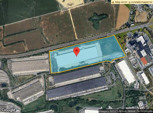
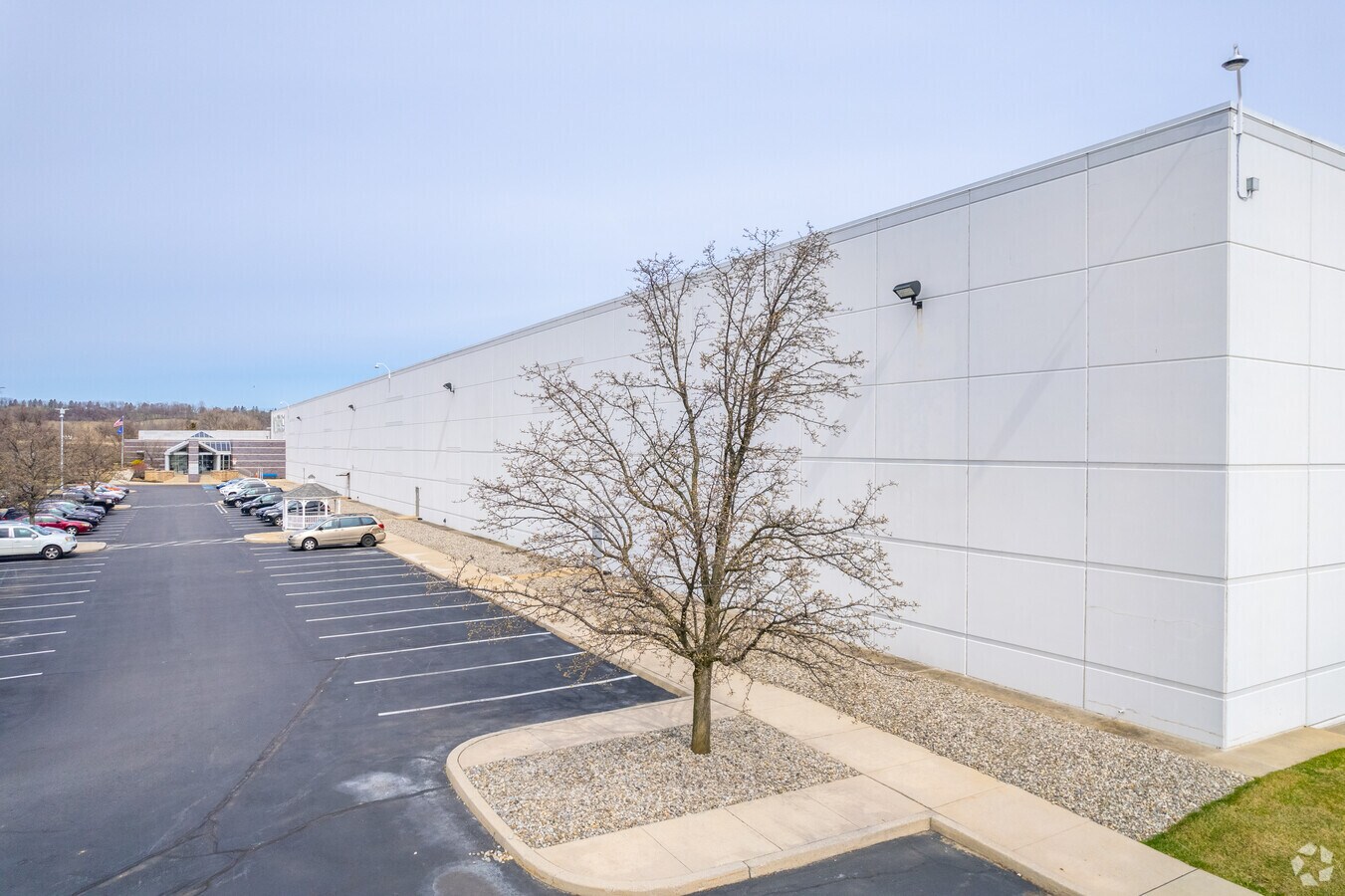
Property Record
555 Nestle Way, Breinigsville, PA 18031

NEARBY LISTINGS FOR SALE OR LEASE
Property Detail
555 Nestle Way
Allentown-Bethlehem-Easton, PA-NJ
Lehigh Valley West
545559099718-1
LOTS: 014
Distributionwarehouseregional
Lehigh
X
Pennsylvania
42011C0210G
14
2024
86 AC
2024
Lehigh Valley
006205
Philadelphia
1,042,665 SF
DEMOGRAPHICS near 555 Nestle Way
1 Mile
3 Mile
5 Mile
2024 Total Population
943
21,365
58,832
2029 Population
929
21,672
59,297
Pop Growth 2024-2029
(1.48%)
+ 1.44%
+ 0.79%
Average Age
41
39
41
2024 Total Households
387
7,729
21,691
HH Growth 2024-2029
(1.55%)
+ 1.54%
+ 0.81%
Median Household Inc
$114,444
$109,255
$104,815
Avg Household Size
2.40
2.70
2.60
2024 Avg HH Vehicles
2.00
2.00
2.00
Median Home Value
$414,458
$350,823
$331,966
Median Year Built
1993
1998
1992
Nearby Places
- Restaurants
- Banks
- Shops
- Fitness
- Groceries
PUBLIC TRANSPORTATION
AIRPORT
Lehigh Valley International
DRIVE
WALK
Distance
Lehigh Valley International
26 min
14.5 mi
Freight Ports
Port of Philadelphia
DRIVE
WALK
Distance
Port of Philadelphia
84 min
62.8 mi
Nearby Properties
Address
Land Use
TOTAL SIZE
Lot Size
Zoning
Address
Land Use
TOTAL SIZE
Lot Size
Zoning
1,155,164 SF
101.05 AC
L1
Address
Land Use
TOTAL SIZE
Lot Size
Zoning
19,055 SF
194.07 AC
LI
Address
Land Use
TOTAL SIZE
Lot Size
Zoning
1,192,380 SF
83.59 AC
LI
Address
Land Use
TOTAL SIZE
Lot Size
Zoning
5,240 SF
137.34 AC
RT
Address
Land Use
TOTAL SIZE
Lot Size
Zoning
999,600 SF
67.99 AC
LI
Address
Land Use
TOTAL SIZE
Lot Size
Zoning
4,990 SF
39.62 AC
R5
Address
Land Use
TOTAL SIZE
Lot Size
Zoning
920,400 SF
65.34 AC
LI
Address
Land Use
TOTAL SIZE
Lot Size
Zoning
789,551 SF
52.39 AC
LI
Address
Land Use
TOTAL SIZE
Lot Size
Zoning
822,162 SF
50.12 AC
LI
Address
Land Use
TOTAL SIZE
Lot Size
Zoning
730,080 SF
44.34 AC
Address
Land Use
TOTAL SIZE
Lot Size
Zoning
730,080 SF
44.96 AC
Address
Land Use
TOTAL SIZE
Lot Size
Zoning
794,880 SF
45.63 AC
LI
Address
Land Use
TOTAL SIZE
Lot Size
Zoning
573,344 SF
38.61 AC
LI
Address
Land Use
TOTAL SIZE
Lot Size
Zoning
4,948 SF
51.05 AC
R3
Address
Land Use
TOTAL SIZE
Lot Size
Zoning
725,760 SF
50.25 AC
LI
Address
Land Use
TOTAL SIZE
Lot Size
Zoning
685,920 SF
83.33 AC
LI
Address
Land Use
TOTAL SIZE
Lot Size
Zoning
4,037 SF
30.51 AC
R5
Address
Land Use
TOTAL SIZE
Lot Size
Zoning
808,418 SF
65.50 AC
LI
Address
Land Use
TOTAL SIZE
Lot Size
Zoning
610,647 SF
46.50 AC
LI
Address
Land Use
TOTAL SIZE
Lot Size
Zoning
607,320 SF
53.44 AC
LI
Address
Land Use
TOTAL SIZE
Lot Size
Zoning
244,481 SF
30.24 AC
LI
Address
Land Use
TOTAL SIZE
Lot Size
Zoning
293,406 SF
48.34 AC
LI
Address
Land Use
TOTAL SIZE
Lot Size
Zoning
525,868 SF
32.38 AC
LI
Address
Land Use
TOTAL SIZE
Lot Size
Zoning
2,310 SF
163.66 AC
R5
Address
Land Use
TOTAL SIZE
Lot Size
Zoning
81,261 SF
41.18 AC
L1
Address
Land Use
TOTAL SIZE
Lot Size
Zoning
480,000 SF
27.94 AC
LI
Address
Land Use
TOTAL SIZE
Lot Size
Zoning
425,093 SF
52.57 AC
GC
Address
Land Use
TOTAL SIZE
Lot Size
Zoning
521,700 SF
35.81 AC
LI
Address
Land Use
TOTAL SIZE
Lot Size
Zoning
499,616 SF
31.08 AC
LI
The World's #1 Commercial Real Estate Marketplace
Connect with us
© 2025 CoStar Group
The information above has been obtained from sources believed reliable. While we do not doubt its accuracy we have not verified it and make no guarantee, warranty or representation about it. It is your responsibility to independently confirm its accuracy and completeness. Any projections, opinions, assumptions, or estimates used are for example only and do not represent the current or future performance of the property. The value of this transaction to you depends on tax and other factors which should be evaluated by your tax, financial, and legal advisors. You and your advisors should conduct a careful, independent investigation of the property to determine to your satisfaction the suitability of the property for your needs.